ဝှာင်:British Empire in February 1952.png

ဇမၞော် နမူနာ ဏအ် - ၈၀၀ × ၃၅၀ pixels အရာမသ္ဂုတ်သွာတ်လဝ်ဂမၠိုၚ်: ၃၂၀ × ၁၄၀ pixels | ၆၄၀ × ၂၈၀ pixels | ၁၄၂၃ × ၆၂၃ pixels တၞဟ်။
ဝှာင် တမ်မူလ (၁၄၂၃ × ၆၂၃ pixels, file size: ၃၆ KB, MIME type: image/png)

|
File:British Empire in February 1952.svg is a vector version of this file. It should be used in place of this PNG file when not inferior.
File:British Empire in February 1952.png → File:British Empire in February 1952.svg
For more information, see Help:SVG. |
 |
သကေမ်
| ကဵုယၟု |
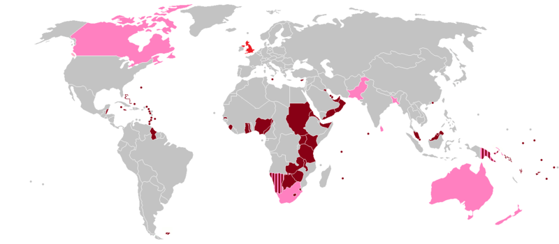
English: A map of the British Empire as it was on 6 February 1952, the day Queen Elizabeth II began her reign. Colonies, protectorates and mandates are shown in dark red, while dominions are shown in pink. The United Kingdom itself is shown in light red. |
| စၟတ်တ္ၚဲ | |
| တမ်ရိုဟ် | https://en.wikipedia.org/wiki/File:BlankMap-World-1957.png |
| ကဝိ | User:Roke~commonswiki |
| တင်မကဵုအခေါင် (ကလေင်သုင်စောဲ ဝှာင်ဏအ်) |
https://en.wikipedia.org/wiki/File:BlankMap-World-1957.png |
မသ္ဂုတ်သွာတ်လာင်ဇြေန်
ဝှာင်ဏအ်ဂှ် စၟတ်သမ္တီလဝ် နကဵုလာင်ဇြေန် Creative Commons Attribution-Share Alike 3.0 Unported ရ၊၊
- မၞးဂှ် ဗွဲမဗၠးၜး -
- သွက်ဂွံ ပါ်ပရအ် – သွက်ဂွံ စၠောအ်ပပ်ပဳ၊ တြးပတိတ်၊ ဗလး ကမၠောန်
- သွက်ဂွံ ပကောံနှဴ – သွက်ဂွံ ပလေဝ်ပညဳ ကမၠောန်
- နကဵု တင်မသ္ဒးဒ္ဂေတ်ဗက် ဗွဲသၟဝ်ဏအ်ဂှ်
- တင်မစှ်ေစိုတ် – မၞး သ္ဒးဒ္ဂေတ်ဗက် သၞောတ်ဝ် မဖျေဟ်လဝ် စပ်ကဵု အစာချူလိက် ဟွံသေင်မ္ဂး တၠမူတအ်ရောင်၊၊ (ဆဂး နကဵုနဲလဵု အကာဲအရာ ဗီုလဵုလေဝ် ဟွံကဵုကသပ် ဟွံထံက်ဂလာန် ကုမၞး ပ္ဍဲအရာမစကာ ဒြပ်ညးတၞဟ်တအ်ရောင်)။
- ပါ်ပရအ် အရာမတုပ်သၟဟ် – ယဝ်ရ မၞး ပလေဝ်၊ ပြံင်လှာဲ ဟွံသေင်မ္ဂး ထပ်ခၞံဗဒှ်တၟိမ္ဂး အရာကမၠောန်တအ် သီုဖအိုတ်ဂှ် သ္ဒးပရးပတိတ် နကဵုသၟဝ် မတုပ် ဟွံသေင်မ္ဂး မသၟဟ် ကုလာင်ဇြေန် ကမၠောန်တြေံဂှ် ဟေင်ရ၊၊
ဝှာင် လၟေင်အပြံင်အလှာဲ
ဍဵု လတူ စၟတ်တ္ၚဲ/အခိင် မွဲမွဲ သွက်ဂွံ ထ္ၜးကဵု ဝှာင် မကတဵုဒှ်လဝ် ပ္ဍဲအခိင်ဂှ်၊၊
| စၟတ်တ္ၚဲ/အခိင် | ဗီုပြင်နမူနာ | ပမာဏ | ညးလွပ် | တင်ပသောင်ကလး | |
|---|---|---|---|---|---|
| လၟုဟ် | ၂၀:၅၁၊ ၂၀ ဂျူလာင် ၂၀၁၅ | | ၁၄၂၃ × ၆၂၃ (၃၆ KB) | Snow Lion Fenian | Darker shade of pink for the dominions, and lighter shade of grey for other countries. |
| ၂၀:၄၉၊ ၂၀ ဂျူလာင် ၂၀၁၅ |  | ၁၄၂၃ × ၆၂၃ (၃၆ KB) | Snow Lion Fenian | Lighter shade of grey, darker shade of pink. | |
| ၂၂:၅၁၊ ၅ ဂျူလာင် ၂၀၁၅ |  | ၁၄၂၃ × ၆၂၃ (၃၆ KB) | Snow Lion Fenian | Vancouver Island to pink. | |
| ၂၂:၄၇၊ ၅ ဂျူလာင် ၂၀၁၅ |  | ၁၄၂၃ × ၆၂၃ (၃၆ KB) | Snow Lion Fenian | Changed Canada to pink, as it was a dominion at the time. | |
| ၂၂:၃၈၊ ၅ ဂျူလာင် ၂၀၁၅ |  | ၁၄၂၃ × ၆၂၃ (၃၆ KB) | Snow Lion Fenian | {{subst:Upload marker added by en.wp UW}} {{Information |Description = {{en|A map of the British Empire as it was on 6 February 1952, the day Queen Elizabeth II began her reign. Colonies, protectorates and mandates are shown in dark red, while dominion... |
ဝှာင် ဗီုဂွံစကာ
အရာမဆက်ဗက်ကၠုင် page links ကုဝှာင်ဏအ် ဂမၠိုင်ဂှ် -
ဝှာင် သွက်ဂွံသုင်စောဲ ဂလုပ်ဗဴ
ဗွဲသၟဝ်ဏအ်ဂှ် ဒှ်အရာ ဝဳကဳတၞဟ် မစကာလဝ် ဝှာင်ဏအ်၊၊
- ဗီုစကာ ပ္ဍဲ af.wikipedia.org
- ဗီုစကာ ပ္ဍဲ bg.wikipedia.org
- ဗီုစကာ ပ္ဍဲ cs.wikipedia.org
- ဗီုစကာ ပ္ဍဲ de.wikipedia.org
- ဗီုစကာ ပ္ဍဲ en.wikipedia.org
- ဗီုစကာ ပ္ဍဲ es.wikipedia.org
- ဗီုစကာ ပ္ဍဲ et.wikipedia.org
- ဗီုစကာ ပ္ဍဲ fa.wikipedia.org
- ဗီုစကာ ပ္ဍဲ fr.wikipedia.org
- ဗီုစကာ ပ္ဍဲ hi.wikipedia.org
- ဗီုစကာ ပ္ဍဲ pt.wikipedia.org
- ဗီုစကာ ပ္ဍဲ ro.wikipedia.org
- ဗီုစကာ ပ္ဍဲ sk.wikipedia.org
- ဗီုစကာ ပ္ဍဲ sr.wikipedia.org
- ဗီုစကာ ပ္ဍဲ trv.wikipedia.org
- ဗီုစကာ ပ္ဍဲ uk.wikipedia.org
- ဗီုစကာ ပ္ဍဲ vi.wikipedia.org
- ဗီုစကာ ပ္ဍဲ zh.wikipedia.org